Copyright (c) 1998 by Timothy C. Barmann. This article is intended for personal viewing only and may not be re-distributed in any form. Please e-mail link requests.
July 19, 1998
Web site offers aerial views
of most sections of Rhode IslandBy Timothy C. Barmann
Last summer, the Internet brought us some amazing pictures from another world, thanks to NASA's Mars Pathfinder mission. This summer, the Web is letting us take a closer look at our own planet.
The site is called TerraServer (http://www.terraserver.microsoft.com/) and it contains millions of aerial and satellite images of cities and towns across the United States and in other parts of the world.
With a few mouse clicks, you can zoom in to see a bird's-eye view of your town, your neighborhood, your house and perhaps even your car. And Rhode Islanders are in luck, because pictures of almost every section of the state are now on-line.
The effort is the result of a collaboration by a government agency and several companies, led by Microsoft. The Redmond, Wash., software giant developed the site to demonstrate software that companies can use to put huge databases on the Internet. TerraServer runs on computers provided by Digital Equipment Corp. of Maynard, Mass.
The images are from two sources. About two-thirds are from the U.S. Geological Survey, the government agency charged with making aerial photographs of the United States to be used for map-making and development planning. The rest of the pictures were supplied by Aerial Images, a Raleigh, N.C., venture. That company has partnered with a branch of the Russian Space Agency, Sovinformsputnik, which has its own giant collection of satellite images. The Russian images, called SPIN-2, show parts of the United States, as well as other parts of the world.
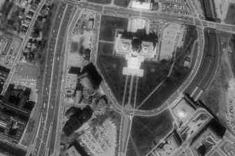
The USGS images, taken from an airplane at 20,000 feet, are one-meter resolution, meaning that the smallest object you can distinguish is about three feet wide. That's good enough to make out buildings and sometimes cars, but not people. The SPIN-2 images, taken from a satellite, are not quite as detailed -- they are two-meter resolution.Microsoft says its TerraServer database holds more than one terabyte of information. That's one trillion bytes, written as a 1 followed by 12 zeros. Microsoft claims TerraServer is the largest database in the world, although that claim was challenged by IBM last week. (IBM says its own Patent Server site -- http://www.patents.ibm.com/ is larger.)
Nevertheless, Microsoft has assembled a fascinating site, though it can be difficult to reach and it can be quite slow to load, especially through a dial-up modem.
In fact, the first week or so after its June 24 launch, the site was unreachable to some. Many who tried to load it saw only an error message that said the Web server was too busy.
That was embarrassing for Microsoft, which touted the site as an example of how its products can handle huge amounts of data.
Microsoft said the site got a lot more attention than it had anticipated and that it didn't initially set up enough Web servers to meet the demand.
"This is not a software or hardware issue. It's just a capacity planning issue," said Doug Leland, lead product manager for Microsoft's SQL server, which runs the TerraServer database, as quoted by News.com.
Microsoft seems to have addressed the problem, as the site was readily accessible this week.
To use the site, you type in a place, such as Providence, and then choose from a list of images. After selecting one, an aerial photograph appears on the screen, which comprises 16 smaller pictures. You can make the image larger on your screen to see more detail, but doing so slows down how fast it loads. You can also locate the area you want to see by clicking on a map, or by entering the longitude and latitude coordinates.
I was able to find several places in Rhode Island, but a real map came in handy at times. The images are from three to seven years old, so that means you won't see the new T.F. Green Airport, or any sign of the Providence Place mall being constructed.
Clicking on an image zooms in to the point where you can make out houses, swimming pools, baseball diamonds, and so forth. But the quality of the images varies. It was sometimes difficult to distinguish a driveway next to a house, but in other cases, you can make out cars on a highway. Clicking on arrows that surround the pictures lets you pan to an adjacent area.
You can download an image to your own computer, if you are using either the Internet Explorer 4.0 or Netscape Navigator 4.0 browsers.
The site also has links to famous landmarks in the United States, such as the Statue of Liberty, the Grand Canyon, the Golden Gate Bridge, and a few places abroad, such as Venice, Italy, and Athens, Greece, where the Parthenon is located.
But there are big gaps in areas that images cover. The site invites you to "Find a spot on Earth," but only 30 percent of the United States is covered, and a much smaller portion of the rest of the world is available.
Rhode Island appears to be the only New England state completely represented in photographs, judging by a map on the site. Coverage in Connecticut and Massachusetts, as well as most of the country, is spotty. You won't be able to look up your favorite beach on lower Cape Cod, but you can zoom in on Fenway Park in Boston.
Beth Nuff, a computer specialist with the USGS, and a coordinator for the TerraServer project, said the agency does have photographs of the entire United States, which are taken on an ongoing basis.
So far, images of only about 30 percent of the country have been converted to digital form. The conversion process is time-consuming and it involves correcting the pictures for distortion, and piecing together overlapping sections. The resulting pictures, called digital orthophoto quadrangle images, look like they were all taken from directly overhead.
The agency continues to convert its photographs to this digital format, Nuff said, and hopes to provide Microsoft with images that cover more than 50 percent of the United States in the next 18 months. Microsoft has committed to maintaining the site for that length of time.
Meanwhile, head to TerraServer and see if you can find your house. It certainly provides a new way to see your back yard.
Timothy C. Barmann is a Journal-Bulletin staff writer. His column runs every other Sunday on the Computers and Technology page. Send him comments via e-mail at tim@cybertalk.com or U.S. mail, c/o the Journal-Bulletin, 75 Fountain St., Providence, R.I. 02902.
![[Cybertalk logo]](ctsm.gif)